

The Chinese government recently released a list of “standardized” names of 11 places in Arunachal Pradesh, which the Indian authorities outright rejected. The Ministry of Civil Affairs of China released the names in Chinese, Tibetan, and pinyin characters, which included two land areas, two residential areas, five mountain peaks, and two rivers. This move is not the first of its kind, as China had previously released two different sets of “standardized” names of places in Arunachal Pradesh in 2017 and 2021.
China’s Claim on Arunachal Pradesh
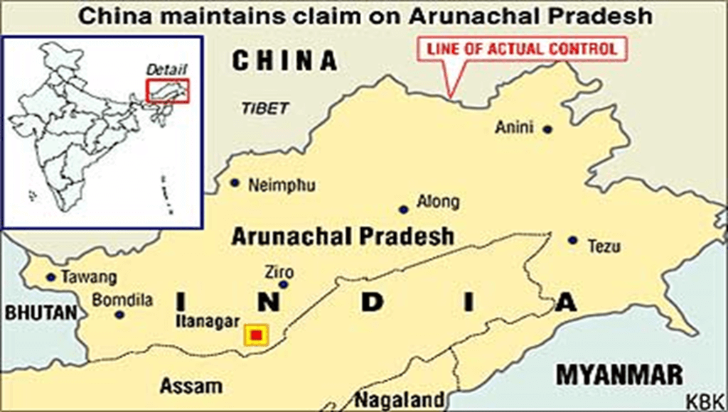
China claims some 90,000 sq km of Arunachal Pradesh as its territory and refers to the area as “Zangnan” in the Chinese language. It makes periodic efforts to underline this unilateral claim to Indian territory, and giving Chinese names to places in Arunachal Pradesh is part of that effort. China’s maps show Arunachal Pradesh as part of China and sometimes parenthetically refer to it as “so-called Arunachal Pradesh.”
Places Featured in Previous Lists
The 2017 list contained six places in the state, namely Wo’gyainling, Mila Ri, Qoidengarbo Ri, Mainquka, Bumo La, and Namkapub Ri. The 2021 list included eight residential areas, four mountains, two rivers, and a mountain pass. The latitude and longitude listed with the names showed those places as Tawang, Kra Daadi, West Siang, Siang (where Mechuka or Menchuka is an emerging tourist destination), Anjaw, and Subansiri, respectively.
China’s Argument for Claiming These Areas
- China disputes the legal status of the McMahon Line, which was the boundary between Tibet and British India that was agreed upon at the Simla Convention in 1914.
- The McMahon Line was drawn from the eastern border of Bhutan to the Isu Razi pass on the China-Myanmar border and was named after Henry McMahon, the chief British negotiator at Shimla.
- China claims territory to the south of the McMahon Line, which lies in Arunachal Pradesh.
- The Chinese representative did not consent to the Simla Convention, saying that Tibet had no independent authority to enter into international agreements.
- China also bases its claims on the historical ties that have existed between the monasteries in Tawang and Lhasa.
Indian Authorities’ Response
The Indian authorities have rejected China’s move outright, saying that the Chinese government has no locus standi to rename any place in Arunachal Pradesh. The Ministry of External Affairs has also stated that these “unilateral actions” cannot change the “historical facts” and the “reality” of the situation. India has always maintained that Arunachal Pradesh is an integral part of the country, and any attempts to change the names of places in the state are unacceptable.
Why In News
After China’s Ministry of Civil Affairs released a list of “standardized” names for 11 places in Arunachal Pradesh, India rejected the move outright, stating that it did not accept Chinese territorial claims over the region. The move by China is seen as a part of its repeated efforts to assert its unilateral claim to Indian territory.
MCQs about China’s Territorial Claims on Arunachal Pradesh
-
What is China’s claim on Arunachal Pradesh?
A. China claims some 90,000 sq km of Arunachal Pradesh as its territory.
B. China claims some 50,000 sq km of Arunachal Pradesh as its territory.
C. China claims some 70,000 sq km of Arunachal Pradesh as its territory.
D. China does not claim any part of Arunachal Pradesh.
-
What is the McMahon Line?
A. The boundary between Tibet and British India agreed upon at the Simla Convention.
B. The boundary between China and Myanmar.
C. The boundary between Bhutan and China.
D. The boundary between India and Pakistan.
-
What is the significance of the Chinese government’s move to release “standardized” names of places in Arunachal Pradesh?
A. It is part of China’s efforts to underline its unilateral claim to Indian territory.
B. It is an attempt by China to acknowledge Arunachal Pradesh as part of India.
C. It is part of China’s efforts to establish friendly relations with India.
D. It is a response to India’s release of standardized names of places in China.
Boost up your confidence by appearing our Weekly Current Affairs Multiple Choice Questions
![]()