
Several geospatial products and solutions firms across India have announced plans to create a Digital Twin of India’s top cities. Digital twin technology is a new development in science and technology that is fast gaining relevance. In this context, this article brings you the details of the digital twin technology from the IAS exam perspective.
What is a Digital Twin?
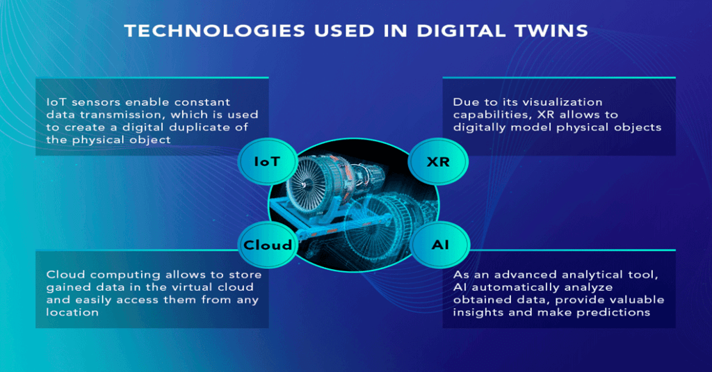
A digital twin is a virtual three-dimensional (3D) representation of an object or system that delivers real-time insights into the performance, operation, or profitability of a physical object, even a city. It is an exact replica of a physical entity created using high-definition geospatial coverage captured through advanced sensors.
How is it built?
The Digital Twin city uses comprehensive, high-definition geospatial coverage in 2D, 3D, 4D, and 360 degrees, captured through advanced sensors. The moving objects on-ground and in the sky, including those from drones, are processed, productized, and published in near-real time using cutting-edge AI/ML, computer vision, data analytics, and geospatial technologies.
Digital Twin of Indian Cities
A Mumbai-based geospatial products and solutions firm called Genesys International announced its plans to create a Digital Twin of India’s top 100 cities. It hopes to complete 20 digital twins by the end of 2024. Another such firm, MapmyIndia, is also working on a 3D digital twin in India. Amaravati, the capital of Andhra Pradesh, is already being built as a digital twin.
Advantages of Digital Twin Technology
Adding engineering and application data layers to the 3D digital twins will improve local governance in terms of public services such as urban governance, disaster management, emergency response, and tourism. 3D digital twins can help in building climate-smart cities or green infrastructure, better healthcare, green environment, smart education, smart agriculture, etc.
The Digital Twin technology will help policymakers improve governance and the urban ecosystem through efficient planning of infrastructure. The use of advanced technologies for better city planning and governance is the need of the hour, given that we are faced with the dual problem of population density and climate change.
National Geospatial Policy 2022
India’s new geospatial policy (National Geospatial Policy 2022) allows firms to collect and create content for such projects. This policy encourages the creation of geospatial data infrastructure in the country, which can be used for various applications like navigation, disaster management, agriculture, and urban planning.
Data Security
Sensitive data on critical city infrastructure must remain within the secured vault to prevent misuse. There is a need to ensure that the data collected is used ethically, transparently, and in the public interest.
Important Points:
- 🏙️ Digital Twin technology creates a virtual three-dimensional representation of an object or system, such as a city.
- 🌐 Digital Twin cities use high-definition geospatial coverage in 2D, 3D, 4D, and 360 degrees captured through advanced sensors.
- 🌿 Digital Twin technology can help in building climate-smart cities, green infrastructure, and a better environment for citizens.
- 📈 Digital Twins can help policymakers improve governance and the urban ecosystem through efficient planning of infrastructure.
- 🇮🇳 Geospatial products and solutions firms in India have announced plans to create a Digital Twin of India’s top cities, with the aim to complete 20 digital twins by the end of 2024.
- 🌍 Other elite cities and countries, such as Singapore, Yingtan in China, Dubai, Saudi Arabia, Auckland, Helsinki, Boston, Colorado, and Orlando, have already started building digital twins of their cities.
- 🗺️ India’s National Geospatial Policy 2022 allows firms to collect and create content for such projects, which will encourage the creation of geospatial data infrastructure in the country for various applications like navigation, disaster management, agriculture, and urban planning.
- 🔐 Data security remains a concern, and there is a need to ensure that the data collected is used ethically and in the public interest.
Why In News
Numerous geospatial firms in India are planning to create Digital Twins of India’s top cities, utilizing a cutting-edge technology known as Digital Twin, which is rapidly gaining prominence in the field of science and technology.
MCQs about Digital Twin Technology
-
What is a Digital Twin?
A. A virtual 2D representation of an object or system
B. A virtual 3D representation of an object or system
C. A virtual 4D representation of an object or system
D. A virtual 5D representation of an object or system
-
Which technology is used to capture geospatial coverage for building a Digital Twin city?
A. Blockchain
B. Advanced sensors
C. Virtual Reality
D. Augmented Reality
-
Which of the following is not a potential benefit of a 3D digital twin city?
A. Building climate-smart cities or green infrastructure
B. Improving healthcare
C. Better governance and infrastructure planning
D. Promoting industrialization and factories
-
Which company has announced plans to create a Digital Twin of India’s top 100 cities?
A. Microsoft
B. Genesys International
C. MapmyIndia
D. Amazon
Boost up your confidence by appearing our Weekly Current Affairs Multiple Choice Questions
![]()