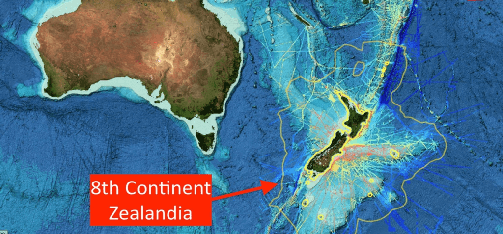
After 375 years of speculation and exploration, scientists have finally confirmed the existence of a “missing” continent known as Zealandia or Te Riu-a-Māui. Zealandia is now recognized as the world’s eighth continent. Zealandia is a long, narrow microcontinent that is mostly submerged in the South Pacific Ocean. This article will explore the origin, location, size, climate, topography, volcanic activity, underwater Zealandia, and how Zealandia fits in the definition of a continent.
Origin:
Zealandia was once part of an ancient supercontinent called Gondwana, which also included Western Antarctica and Eastern Australia over 500 million years ago. Zealandia began to pull away from Gondwana roughly 105 million years ago. It gradually sank beneath the waves, with over 94% of the landmass remaining underwater for millennia. The existence of Zealandia was first recorded in 1642 by Dutch businessman and sailor Abel Tasman.
Location and Size:
Zealandia is a microcontinent that broke off from Antarctica about 100 million years ago, and then from Australia about 80 million years ago. This continent is approximately 1.89 million square miles in size, about half the size of Australia, but only 7 percent of it is above sea level.
Most of that terrestrial land makes up the two large islands of the country of New Zealand – the North Island and the South Island. Stewart Island, just south of the South Island, and many smaller islets are also a part of Zealandia. New Caledonia, a collection of islands governed by France, makes up the northern tip of Zealandia.
Climate:
Zealandia generally enjoys a mild, temperate climate. The tropical climate of New Caledonia has more in common with Oceania and the South Pacific.
Topography and Volcanic Activity:
- Zealandia’s largest islands have glaciers, with the Tasman Glacier on the South Island being the largest.
- Activity from the last glacial period carved out many fjords and valleys in the region.
- Zealandia is a very tectonically active region, with part of the microcontinent on the Australian plate and the other part on the Pacific plate.
- There are six major areas with active volcanoes in Zealandia, with the Taupo Volcanic Zone on the North Island being the largest.
- Geothermal activity caused by the interaction of the Australian and Pacific plates means there are many natural geysers and hot springs scattered throughout Zealandia.
- The North Island is dominated by the North Island Volcanic Plateau, while the primary mountain range of the South Island is the Southern Alps.
- Both mountain ranges are slowly getting higher through a process called tectonic uplift.
Underwater Zealandia:
The submerged part of Zealandia is rich in mineral deposits. New Zealand’s government strictly controls undersea mining activity. The microcontinent of Zealandia helps determine New Zealand’s Exclusive Economic Zone (EEZ). A country may use any natural resources, such as oil or fish, in its EEZ without permission from another organization.
New Zealand’s EEZ is about 4.3 million square kilometers, more than 15 times the amount of land above ground. There are also many natural gas fields scattered throughout Zealandia. The Maui natural gas field in the Tasman Sea is the largest.
What makes a continent a continent?
Geologists define a continent as a major land mass, including both dry land and the continental shelves that lie off the coast. A continent is made of continental crust – a base of igneous, metamorphic and sedimentary rocks. Oceanic crust is made up of basalt and is thinner and denser than continental crust. A continent should also have areas of high elevation when compared to the surrounding seabed. There is no minimum size requirement for a continent.
How zealandia fits in the definition
- Zealandia meets the criteria of being a continent as it is a continuous expanse of continental crust, physically separated from Australia’s continental crust, and significantly elevated, rising about 3,000 m above the surrounding oceanic crust.
- Zealandia is linked together by the islands of New Caledonia to the north, North, South, and Stewart Islands, the Auckland Islands and Campbell Island to the south, and the Chatham Islands to the west.

Why In News
After years of exploration and research, scientists have officially confirmed the existence of Zealandia, an almost entirely submerged continent, and it is now recognized as the world’s eighth continent. This discovery could help researchers better understand the geological and biological evolution of the planet.
MCQs on Importance of Zealandia
-
What is the largest glacier in Zealandia?
A. Fox Glacier
B. Tasman Glacier
C. Franz Josef Glacier
D. Mendenhall Glacier
-
What process is causing the mountain ranges in Zealandia to slowly get higher?
A. Erosion
B. Tectonic uplift
C. Volcanic activity
D. Climate change
-
What is the name of the largest volcanic zone in Zealandia?
A. Taupo Volcanic Zone
B. Yellowstone Caldera
C. Mount St. Helens
D. Krakatoa
-
What is the name of the microcontinent that Zealandia is part of?
A. Australia
B. Pacifica
C. Gondwana
D. None of the above
-
What is the elevation of Zealandia above the surrounding oceanic crust?
A. 500 meters
B. 1,000 meters
C. 2,000 meters
D. 3,000 meters
Boost up your confidence by appearing our Weekly Current Affairs Multiple Choice Questions
![]()


