

Daily Current Affairs : 13-July-2023
In a significant stride towards bolstering maritime navigation and ensuring safer waters, the Ministry of Ports, Shipping, and Waterways has recently launched the indigenous Differential Global Navigation Satellite System (DGNSS) known as ‘Sagar Sampark.’ This revolutionary system is designed to enhance the accuracy and reliability of the existing Global Navigation Satellite System (GNSS), thereby improving the positioning information for mariners and mitigating potential risks of collisions, groundings, and accidents in port and harbor areas.
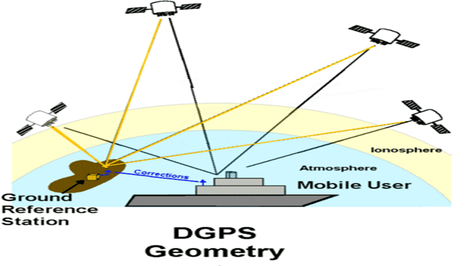
Understanding DGNSS
DGNSS, also known as Differential GNSS, is an enhancement system that operates on terrestrial ground stations. Its primary purpose is to correct errors and inaccuracies that may arise in the GNSS signals. The GNSS, which includes the popular GPS (Global Positioning System) from the USA and GLONASS (Global Navigation Satellite System) from Russia, provides satellite-based positioning information. However, these systems may suffer from slight discrepancies, leading to less precise location data.
Key Benefits of Sagar Sampark
- Ensuring Safer Navigation
One of the primary advantages of Sagar Sampark is its ability to facilitate safer navigation for mariners. By providing more accurate positioning information, ships can confidently maneuver through busy waterways, reducing the risk of accidents and ensuring smoother operations in ports and harbors.
- Reducing Collision Risks
Collisions at sea can have disastrous consequences. With the implementation of Sagar Sampark, the chances of maritime accidents due to inaccurate positioning information are significantly reduced. This, in turn, protects both human lives and the environment.
- Enhanced Availability and Redundancy
Sagar Sampark not only improves accuracy but also enhances the availability and redundancy of positioning data. This is crucial, especially in remote or difficult-to-access areas, where relying solely on one navigation system may be insufficient.
- Improved Positioning Accuracy
Before the introduction of Sagar Sampark, mariners faced an average error correction accuracy of 5 to 10 meters. However, with the new system, this accuracy has been significantly enhanced to less than 5 meters for locations up to 100 nautical miles from Indian coastlines. This remarkable improvement empowers mariners with more precise navigation capabilities.
Implementation of Sagar Sampark
The successful implementation of Sagar Sampark involves a well-coordinated effort between the Ministry of Ports, Shipping, and Waterways and relevant technological agencies. The key steps in the deployment include:
- Ground Stations Installation
To establish the DGNSS infrastructure, ground stations equipped with advanced technology have been strategically set up across coastal regions of India. These stations receive signals from the existing GNSS satellites and transmit necessary corrections to ships within their coverage area.
- Satellite Compatibility
Sagar Sampark has been designed to receive and transmit corrections from both the GPS (USA) and GLONASS (Russia) satellite systems. This compatibility ensures seamless integration with existing global navigation networks and enhances its utility for international mariners.
- Continuous Monitoring and Upgrades
To ensure the optimal performance of Sagar Sampark, the ground stations are continuously monitored and regularly upgraded as per international standards. This dedication to maintenance guarantees that mariners can rely on the system for safe and accurate navigation.
Important Points:
- The Ministry of Ports, Shipping, and Waterways launched the indigenous Differential Global Navigation Satellite System (DGNSS) called ‘Sagar Sampark.’
- DGNSS is a terrestrial-based enhancement system that corrects errors in the Global Navigation Satellite System (GNSS), providing more accurate positioning information.
- Sagar Sampark aims to improve maritime navigation, reduce collision risks, and prevent accidents in port and harbor areas.
- The system enhances availability and redundancy as per international standards, offering mariners positioning accuracy within 5 meters.
- Sagar Sampark can transmit corrections of both GPS (USA) and GLONASS (Russia) signals.
- The error correction accuracy has been improved from 5 to 10 meters to less than 5 meters for locations up to 100 nautical miles from Indian coastlines.
- The ground stations play a crucial role in the implementation of Sagar Sampark, receiving signals from GNSS satellites and transmitting corrections to ships.
- Sagar Sampark’s compatibility with GPS and GLONASS ensures seamless integration with existing global navigation networks.
- Continuous monitoring and upgrades of ground stations are done to maintain optimal system performance.
- Sagar Sampark contributes to safer navigation, protecting human lives and the environment.
- India’s investment in innovative solutions like Sagar Sampark demonstrates its commitment to the maritime industry’s growth and ecological preservation.
Why In News
The Ministry of Ports, Shipping, and Waterways proudly unveiled ‘Sagar Sampark,’ an indigenous Differential Global Navigation Satellite System (DGNSS) that promises to revolutionize marine navigation and enhance the safety and efficiency of maritime operations. This cutting-edge system will not only bolster India’s maritime capabilities but also foster technological advancements in the field of satellite navigation on a global scale.
MCQs about India’s Indigenous DGNSS – Sagar Sampark
-
What is the primary purpose of the Differential Global Navigation Satellite System (DGNSS) known as ‘Sagar Sampark’?
A. Enhancing communication in port and harbor areas.
B. Correcting errors and inaccuracies in the Global Navigation Satellite System (GNSS).
C. Transmitting weather updates to mariners.
D. Monitoring marine pollution.
-
What accuracy improvement has ‘Sagar Sampark’ brought to the existing positioning data for locations near the Indian coastlines?
A. Less than 5 meters for 50 Nautical Miles.
B. Less than 10 meters for 100 Nautical Miles.
C. Less than 5 meters for 100 Nautical Miles.
D. Less than 2 meters for 50 Nautical Miles.
-
What is the benefit of Sagar Sampark’s compatibility with both GPS (USA) and GLONASS (Russia) satellite systems?
A. It ensures smoother maritime operations.
B. It provides real-time weather updates.
C. It enhances the availability and redundancy of positioning data.
D. It reduces fuel consumption for ships.
-
How does Sagar Sampark contribute to safer navigation and the prevention of accidents in port and harbor areas?
A. By providing real-time information on maritime traffic.
B. By reducing the risk of collisions, groundings, and accidents through accurate positioning data.
C. By offering free communication services to ships.
D. By broadcasting navigational maps to all ships in the vicinity.
Boost up your confidence by appearing our Weekly Current Affairs Multiple Choice Questions
![]()