

The Indian government has recently notified the National Geospatial Policy 2022, aimed at liberalizing the field of geospatial data. This policy replaces the National Map Policy of 2005 and is based on guidelines issued by the Department of Science and Technology. In this essay, we will discuss the vision, goals, institutional framework, and significance of the National Geospatial Policy.
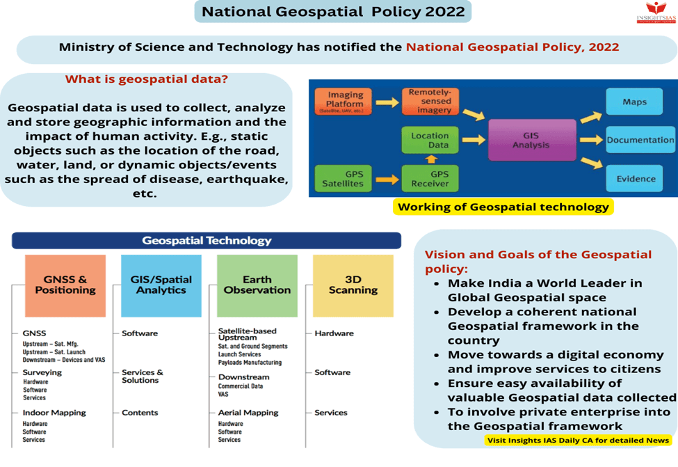
Vision and Goals of NGP 2022
The National Geospatial Policy aims to strengthen the location-centric industry to support national development, economic prosperity, and the information economy. The policy has the following vision and goals:
- To make India a global leader in the geospatial sector that facilitates innovation.
- To develop a coherent national framework and improve services to citizens.
- To ensure easy availability of geospatial data.
- To involve private industry in a thriving geospatial industry.
Institutional Framework
The Geospatial Data Promotion and Development Committee (GDPDC) will be constituted at the national level to formulate and implement strategies/policies/guidelines as an apex body for the sector. It would replace and subsume the functions of the National Spatial Data Committee. The Department of Science and Technology will continue to be the nodal department for the government regarding the geospatial sector.
Significance of the policy
The National Geospatial Policy is a significant step towards making geospatial data and technology agents of transformation in achieving Sustainable Development Goals (SDGs). The policy aims to bring efficiency, accountability, and transparency at all levels of governance. It recognizes the importance of locally available geospatial data and planning in better resource management.
The policy aims to create a conducive ecosystem for Indian companies in the geospatial sector and make India ‘Atmanirbhar’ (self-reliant). It seeks to attract international best practices, enable and support innovation, capitalize on evolving technology in the geospatial sector, and help in the field of education and capacity building. The continued liberalization will promote ease of doing business.
Important Points:
- 🌎 The National Geospatial Policy aims to liberalize the field of geospatial data in India.
- 🏭 The policy intends to strengthen the location-centric industry to support national development and economic prosperity.
- 🎯 The vision of the policy is to make India a global leader in the geospatial sector that facilitates innovation.
- 📈 The policy seeks to involve private industry in a thriving geospatial industry.
- 🗺️ The Geospatial Data Promotion and Development Committee (GDPDC) will be constituted to formulate and implement strategies and policies as an apex body for the sector.
- 💡 The policy aims to enable and support innovation and capitalize on evolving technology in the geospatial sector.
- 🌍 The policy intends to make geospatial data and technology agents of transformation in achieving Sustainable Development Goals (SDGs).
- 💻 The policy aims to bring efficiency, accountability, and transparency at all levels of governance.
- 🌳 The policy recognizes the importance of locally available geospatial data and planning in better resource management.
- 🇮🇳 The policy aims to create a conducive ecosystem for Indian companies in the geospatial sector and make India ‘Atmanirbhar’ (self-reliant).
- 🌐 The policy seeks to attract international best practices and promote ease of doing business.
Why In News
The National Geospatial Policy was notified by the Government of India on December 28, 2022, with the aim of liberalizing the use, gathering, storing, and mapping of geospatial data. Prior to 2021, the sector was strictly regulated in India.
MCQs about Vision and Significance of the National Geospatial Policy in India
-
The National Geospatial Policy aims to:
A. Liberalize the field of geospatial data
B. Strictly regulate the use of geospatial data
C. Reduce the availability of geospatial data
D. None of the above
-
What is the purpose of the Geospatial Data Promotion and Development Committee (GDPDC)?
A. To formulate and implement policies/guidelines for the sector
B. To replace and subsume the functions of the National Spatial Data Committee
C. To make suitable recommendations
D. All of the above
-
What is the vision of the National Geospatial Policy?
A. To make India a global leader in the geospatial sector
B. To develop a coherent national framework and improve services to citizens
C. To ensure easy availability of geospatial data
D. All of the above
-
What is the significance of the National Geospatial Policy?
A. It intends to make geospatial data and technology as agents of transformation in achieving Sustainable Development Goals (SDGs)
B. It recognizes the importance of locally available geospatial data and planning in better management of resources
C. It aims to create a conducive ecosystem for Indian companies in the geospatial sector and make India ‘Atmanirbhar’ (self-reliant)
D. All of the above
Boost up your confidence by appearing our Weekly Current Affairs Multiple Choice Questions
![]()